

Scout Outdoor-Navigation für Radfahren und Wandern app for iPhone and iPad
Developer: MTS Maschinentechnik Schrode AG
First release : 01 Jun 2010
App size: 15.02 Mb
Scout is your iPhone companion for outdoor activities. Make use of topographic maps for hiking adventures or check your training data with the integrated speedometer. Further you can use Scout for cycling and other activities to record your tours for subsequent analysis. Outdoor-Navigation on recorded tracks is also very easy and works without an online connection.
SPECIAL FEATURES
Cyclometer and trip recording in background
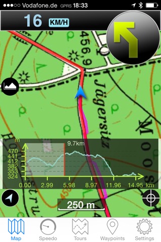
Navigation with a map in the direction of travel and acoustic offside warning
Track import and export with iTunes Filesharing, E-Mail and Safari (GPX Files)
Create Waypoints and use them for navigation (e.g. Geocaching)
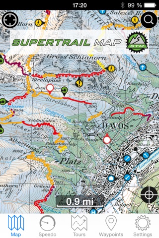
Contains worldwide OpenStreetMap and OpenCycleMap with bike paths and contour lines
Expandable (In-App Purchase) with official topo maps for Denmark, Germany, Austria, Switzerland, France, Great Britain, Luxembourg, Belgium and Netherlands for offline usage. KOMPASS- Outdoormaps are also available for parts of Italy and Spain.
Supertrail Maps and Freeride Maps can now be used as digital maps with the Scout-App including special tours.
MAPS (online/offline)
Scout makes use of the so called Open Street Map. This worldwide map shows major information for streets, paths and towns. Via touch screen it is easy to move and zoom the digital map.
In addition you can download detailed topographic maps in our Map Store with scale 1:50.000. These maps are perfect for activities in the outback, because they show even small field paths. You get everything digital, handy and low priced. These special maps can be used on all devices connected with your iTunes Account
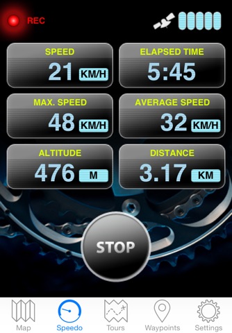
SPEEDOMETER
You can choose which information you see in six defined fields. While on tour you get reliable information on:
Actual speed
Average speed
Maximum speed
Pace (minute / km)
Number of recorded points
Coverage of total distance
Overall time
Actual altitude
Lowest and highest points
Display of GPS signal
GPS accuracy
Heart rate (in combination with a Bluetooth Smart device)
For low-current usage during recording you are able to switch to standy-modus (top right button at your iPhone)
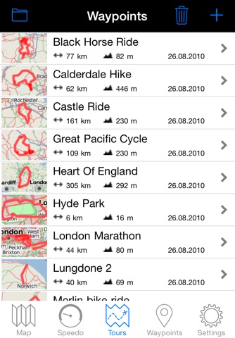
TOURS
You will find all recorded tour data easily in an overview: course of your tour, altitude difference and date of recording
Lenght of tours
Travel time
Average pace
Lowest and highest points
Personal rating (landscape, condition, technique, experience)
You like to have a closer look on your tour later at the PC? You want to exchange your tours with friends? Not a problem at all: you can send your recorded tours via email as common gpx file.
SETTINGS
Here you find all settings for your Scout iPhone app, like downloads of topographic, detailed maps (Wi-Fi connection recommended) to be independent from an online connection later when in nature. Likewise you can define a favored measure (metric or US) or the setting how you record tours (optimized, time and distance interval). The Online-Help gives you an easy introduction to all functions.
Please note: Continued use of GPS running in the background can dramatically decrease battery life.
Latest reviews of Scout Outdoor-Navigation für Radfahren und Wandern app for iPhone and iPad
Annoying is the always disappearing downloaded offline maps and that is the main reason for my 2-star rating. Maps are often also innacurate with regards to hiking trails and show old no longer existing trails. Otherwise a good and useful app.
Can you sell Canada maps? I hike in Banff national park in Alberta Canada.
Today updated to the new version. Now the program stop working - does not load at all!
Map store only contains maps of major parks as far as us maps go
There was nothing local in this ap. I live Oregon/Washington and it had some major parks bur NOTHING I need or can use right now. It didnt even have the street view- additional maps also cost money.. Dont bother with this ap at this point.